Total distance 19.7 miles
Minimum altitude 6,306 feet
Maximum altitude 8,538 feet
I arrived in Lake Tahoe on the last day of September planning to get an early jump on the trail starting at Spooner Summit the next morning. That morning I started my day at Tunnel Creek Café for great cup of coffee and to bum a ride with the bike shuttle driver from the Flume Trail Bikes up to Spooner Summit. I had to wait a little while so they could gather enough mountain bike riders to make the trip worthwhile – then we were off for the summit. I had to hike a quarter-mile back down the road to get to the Spooner picnic area to start my hike. It was a beautiful fall day that inspired several others to get out on the trail and enjoy the weather. I briefly stopped and chatted with everybody who would talk to me, but kept on moving.
At the trail junction to Marlette Lake Trail I came upon a spring that was still flowing under the road even this late in the season. The trail and road rises quickly moving away from Spooner Summit and lake. Two hike-in cabins are available for rent from Spoonersummit.com. Several spur trails branch off of the main trail – they are flagged for cross-country skiing that connects with the Marlette Lake Trail. You pass the first of three approved campgrounds in the Nevada State Parks system for that area. North Canyon Campground is the first providing vault toilets and picnic tables for about six campers. It is also an opportunity to rejoin the Tahoe a Rim Trail, 1.2 miles to the ridge.
One can see the trail zig-zagging its way across the face of Snow Valley Peak up to the ridge line. The other two campgrounds are Marlette Peak and Hobart Reservoir. I will be staying at Marlette Peak Campground tonight. Recently I noticed mile markers placed there by a joint effort between the Boy Scouts of America and the US Forest Service. Very helpful if something goes wrong and you need to tell somebody where you are. After an arduous climb of 16% or more out of the valley you arrive at the pass dropping down to Marlette Lake. With a valid Nevada fishing license, fishing is allowed Marlette Lake from July 15 through September 30, using barbless hooks and no bait – catch and release only. Unfortunately there is no camping allowed in the Marlette Lake Basin – understandable but unfortunate, as it would’ve made a beautiful sunrise camping out at the lake. So I pressed onward, to the Marlette Peak Campground, 4 miles ahead.
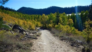
From the lake the road meandered northward in and out of Aspen Groves bringing me to another very steep section. It was going to be pretty slow going for a while. Finally arriving at the crest there were signboards and benches placed there by the Nevada state parks department. One sign explaining how Marlette Lake came into being and one of the rules and regulations for the area. No time for that now, I needed to make camp and I still had a couple of miles to go. I soon descended along the access road and puddles of water from recent rains. It was good to see that the parched forest got a little sip of water from this long drought.
After a while the trail opened up into a sandy clearing connecting the trail junction to the Tahoe Rim Trail. This was all pretty familiar to me now, just backtracking along the route my hiking friends, Tamara, Chris, and Chuck and I were on earlier in September.
After one more climb switchbacking up to the ridge I came upon another trail junction – one leads to the Marlette Peak North West Tahoe Rim Trail (A side trip taking you around the west side of Marlette peak displaying great views of Marlette Lake and Lake Tahoe) Another spur trail called the Sunflower Trail leading to Hobart Reservoir, and the trail I was taking, the north east route to Marlette Peak on the Tahoe Rim Trail leading to Tahoe Meadows, 13 miles to the north.
As the trail meandered through a small grove of fir trees, reminiscent of the sights and smells of a Christmas tree lot – telling me that fall and winter were upon us.
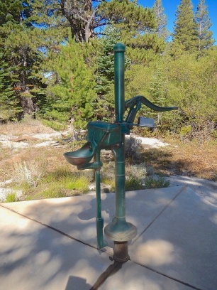
Finally I arrived at the familiar sight the Marlette Peak Campground where Tamara, Chris and Chuck and I camped out for the night in early September. Not a soul was there, just the vault toilets and me. I got my pack off, and made the trip down to the well to get some water. I spoke about this well before… looks like a throwback to the old west, where you had to pump the water 10 or 12 times to get that cold, pure spring water. Soon I’ll have some water boiling for a Cup-a-soup and tea before bedding down for the night.
I was freezing my buns off so I couldn’t wait to get into my new Marmot Helium sleeping bag that I just got off of eBay. Finally I was the winning bid on something! I stashed everything in the bear boxes that they had provided in the campground and got into my cozy new sleeping bag and MSR Hubba one-man tent. I thought somewhere between the soup, the tea, and the new sleeping bag I would be warm and toasty in no time – but no. You know when you get a bone chill and you just can’t seem to warm up no matter what you do? That’s where I was, shivering myself to sleep by about midnight.
Guess I wore myself out shivering so much.
Dawn came too early, getting me out of the rack by 0630. I checked my Garmin GPS had a temperature sensor on it and it had recorded 25°F as the lowest temperature throughout the night and a balmy 29°F at breakfast. After guzzling down 2 cups of my Starbucks Via instant coffee that somehow still tasted like my Cup-o-Soup from the night before, I was packed and ready to hit the trail. I would have to eat my Cliff Bar on the road.
The rain puddles that I had passed the day before had turned to ice skating rinks as I passed them today. It was quite brisk, but I was fairly comfortable except for my fingers that I wasn’t able to feel just yet. The steep section that took forever to get up yesterday went quite quickly this morning. That was the good thing – then that uncomfortable feeling I have had before – that feeling as though you were being watched. I scanned 360° around me, on my way back down to the lake which couldn’t come soon enough.
I made my way out to Chimney Point, a finger that juts out into the lake with an old stone chimney on it. If a cat wanted me bad enough he would have to jump in the lake and come get me. And I know that kitty cats do not like water, so that was my plan for now.
The walk on the road was beautiful in the early morning light. The sun rising over the ridge made all of the fall colors come alive. I arrived at the fir tree that blocked my path last May on my mountain bike – it must have been 6 to 8 feet in diameter. The Forest Service had removed it from the road and it was clear sailing this time. Once arriving at the dam, I took one look back at the mountain and the trail that I had climbed over last month bidding farewell until next season.
Now I was once again on familiar ground, the Flume Trail. Marlette Lake water system and flume was originally created to provide water for the silver mining boom, headquartered in Virginia City, Nevada.
The mines required vast amounts of water to operate and Virginia City needed lumber for housing in the new boomtown. Now a single-track mountain bike and hiking trail connecting Marlette Lake and Tunnel Creek Road near Incline Village, the Flume Trail offers unparalleled vistas of Lake Tahoe to the west and south for most of the hike. (As I have mentioned before, Flume Trail Bikes will rent you a bike and shuttle you to Spooner Summit, and then you can ride back down the mountain to the Tunnel Creek Café, return your bike and have lunch and a beer.)
My trip this time back down the mountain took a little longer, as I didn’t have a bicycle to make the trip go faster. The trail is about 2 feet wide for most of the way, hugging the cliff closely with rock ledges and overhangs making it difficult for passing bikes along the way. The trail can be dicey at times, as the crumbling granite can make for a loose footing. You will meet mountain bikes going both ways, so make sure you make a little noise approaching blind corners.
The mountain bikers are usually expecting other bikes, and I find they get a little spooked when they come across a backpacker. Try not to take your half of the trail out of the middle.
After several miles, the trail joins another trail junction – to the right will take you up to the ridge where the Tahoe Rim Trail connects Tahoe Meadows to the Spooner Summit segment of the TRT. Continuing on straight ahead, the trail becomes a service road for the remainder of the journey back to Tunnel Creek Café. The trail is mostly shaded for another mile and one half, opening up to the afternoon sun the remainder of your hike.
Several hundred feet from the Tunnel Creek Café is a chain-link fenced property, home to the old Ponderosa Ranch of the 1950’s and 60’s TV show, “Bonanza“. The property has since been closed to the public since 2004.
Well I am finally back at my car and the café, tired and hungry. JP set me up with a great turkey and pesto sandwich washed down with a cold Gatorade. What a treat to have a hot homemade sandwich instead of trail food! I don’t think I moved an inch since I sat down an hour ago. Time to head over to the west side of the lake at Kaspian campgrounds and put my senior discount card to work one more time. Just the thought of having a legal campfire tonight was warming me up already. As if we never get enough, I read myself to sleep reading “The Cactus Eaters”, a saga about a young couple’s adventures along the PCT. The next morning I broke camp at 0730 and made a mad dash to my other favorite café, the Firesign Café for a hot breakfast and endless hot coffee.
A great ending to another great trip at Lake Tahoe.
GPS tracks below:
http://connect.garmin.com:80/activity/embed/605202517
http://connect.garmin.com:80/activity/embed/605202521


